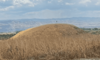
Tel Nisha, also called Tel Neshem and in Arabic Tel al-Manshiya, is a prominent, medium-sized hill, east of Highway 200 – from the direction of Ein Hanziv towards Kibbutz Neve-Eitan. The mound was documented by the British Mandate and surveyed by Nehemiah Tzuri. The mound was not excavated.
The mound is part of dozens of mounds from biblical times that are in the Beit Shean Valley, the most important of which are Beit Shean and Tel Rehov. Prof. Mazar defines all the cities around Tel Rehov from the royal period as “daughters of Rehov”. Tel Nisha was ruled during the monarchy by Tel Rehov and indeed its ceramics are the same as Rehov in the 9th – 10th centuries BC.
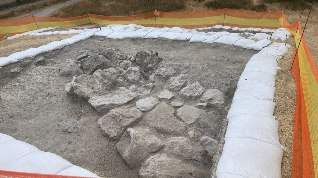
The height of the mound is about 10-15 meters and its size is about 5 dunams. To the southwest of the hill spring springs, which form Nahal Eitan and Adi al-Manashia, which descends to the Jordan from the east. The spurs basically crown half of the mound, which makes it impassable from these directions. Pottery from the Early Bronze I, Late Bronze, and Iron I-II periods were discovered in the mound. And it seems that it was some kind of administrative building. N. Tzuri writes: on the eastern and southern slopes of the hill, stone and brick walls are exposed, while in the extreme southern corner a brick structure is exposed, like a tower (Nehemiah Tzuri 1962).
It is possible to notice the remains of mud walls in the western upper part of the mound, apparently the remains of the city walls from the middle of the ninth century that were destroyed by King Hazal of Aram-Damascus. It is impossible to prove this because there are other Iron Age ruins in the Beit Shean Valley, but the assumption is reasonable in light of the nearby Tel Rehov excavations. It is possible that in the future the mud bricks will be taken for a magnetic test that will determine if it is a Hazal ruin, a placer discovery or a Shishak.
Candles, a pitcher with a strainer, ceramics painted in wild green, cooking pot handles, two alabaster vessels, two bowls, a zoomorphic vessel, limestone egg-shaped loom weights and a local alabaster and a bronze arrow were found in the mound. The mound is very well preserved, and from it there is an impressive view of the entire Beit Shean valley and towards the Jordan. The site appears in the archive file of the Mandatory Antiquities Authority, and it is noted that the upper part of the mound is cultivated (1932). Below is part of what was written on the mound:
An archaeological survey from 1932 reported: a fairly large mound that appears to have pottery in it from the 3rd millennium BC. The upper part of the mound is cultivated. There is a small spring of water that originates and surrounds the site from the southwest and from there continues to flow eastward and essentially creates a natural fortification / moat with Water in part of the mound. It is possible that there are graves on the sides of the mound in the southwest direction. The surveyor Ras added: “Three large and rough stones that were built as part of a wall were exposed by the influence of the heavy rain on the eastern corner of the upper end. Russ probably meant an Iron Age II mudbrick wall at this location.
This is probably the outer wall of the old upper settlement. The reviewers concluded: “recommended excavation”.
Currently an excavation is been don by Yoav Vaknin