

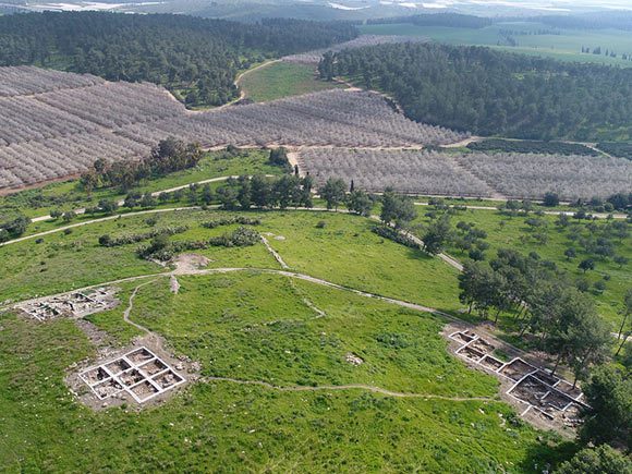
Khirbet el-Rai is located on the southern bank of the Lachish Stream, at a height of about 212 m. above sea level. It is surrounded on three sides by steep slopes. The site forms an excellent view of the Lachish valley, as well as the cities on the Philistine coastal plain to the west, the Judean Mountains to the east, and the northern section of the Shephelah. According to the site’s excavators, the site was located parallel to Ashkelon, in the same way as Khirbet Qeiyafa was located in front of Gath. At the site, a proto-Canaanite inscription bearing the name “Jerubba’al” was discovered.
Research history
The site was first documented in the 19th century by the Palestine Exploration Fund (PEF). Initially, it was known by the name “Tôr el Hiry”, but in later British maps the name “Khirbet al-Ra’i” appeared. In the 1950s, the antiquities were damaged in the eastern section of the site by forestation activities. Only in the 1990s, after an extensive wildfire, an archaeological survey took place at the site under Yehuda Dagan of the Israel Antiquities Authority (IAA). Later, another survey was conducted by Sa’ar Ganor, Yshayahu Lender, and Maya Oron. Since 2015, an archaeological expedition is excavating the side under the supervision of Yosef Garfinkel of the Hebrew University and Sa’ar Ganor of the IAA. The excavation is part of the archaeological project to examine the beginning of the Iron Age IIa period (10th century BCE) in the Shephelah region (which began in 2007).
The findings at the site and the question of its beginning
The earliest evidence of settlement at the site are imported pottery sherds, including Cypriot “Milk Bowls” (14th-13th centuries BCE). The settlement from that period was not discovered. The earliest remains of the settlement are of a fortified site from the second half of the Iron Age I and the beginning of the Iron Age IIa (11th-10th centuries BCE). The ceramic finds include typical Philistine Ware. A structure with an outer wall measuring 1.6 meters was discovered, and later four structures that were connected to it were excavated, dated to the latter half of the 11th century BCE. It was inferred that the walls of these structures were erected using large stones with cavities, on which mudbricks were placed. A considerable amount of clay loom weights, some of which are half-baked, were among the finds. In 2019 an ostracon (dye inscription on pottery), bearing the name “Jerubba’al” was discovered within a silo. Based on the finds from the site, the researchers reconstructed the historical background of Khirbet el-Rai. With the end of the Late Bronze Age (12th century BCE), a process of decline in settlement occurred in the Shephelah region. The fortified site at Khirbet el-Rai replaced the urban center at Lachish and was probably linked to the Philistines.
Later pottery sherds dated to the Iron Age IIb-c (9th to 6th centuries BCE) were also discovered, but not in relation to any architecture. A small settlement from the Persian and Hellenistic periods was discovered. Other finds dated to the Roman, Byzantine and Early Islamic period were also discovered but with no settlement remains. The last period of visible settlement was the Ottoman period (16th-20th centuries CE).
A 150 years-old mystery: Biblical Ziklag’s identification
In the opinion of the excavators of Khirbet el-Rai, it should be identified with biblical Zaanan or biblical Ziklag, which according to the biblical narrative was given to King David by the king of Gath, after he fled the oppression by King Saul. From Ziklag, David left to his coronation at Hebron. Already in the 15th century CE there was an interest in the location of biblical Ziklag. Some fifteen locations were already suggested for its identification in the region of Judah. Ziklag appears 15 times in 12 verses in the Old Testament – in the lists of cities of the Tribe of Judah and Tribe of Simeon and in the list of the Returnees to Zion from the Babylonian Captivity. One of the understandings of the name “Ziklag” is that the name is of Mycenean origin and means “White Walls,” which is explained by the white rocks in the region.
Sources:
Keimer, K. H. (2022): “Biblical Ziklag: the Case for Khirbet er-Ra‘I”, Palestine Exploration Quarterly: pp. 1-20
Garfinkel Y. & Ganor. S. (2018). “Khirbet al-Ra’i near Lachish”. In: Shai, I., Chadwick, J.R., Hitchcock, L., Dagan, A. and Uziel, J. (eds.); “Tell it in Gath: Studies in the History and Archaeology of Israel. Essays in Honor of A. M. Maeir on the Occasion of his Sixtieth Birthday”. Ägypten und Altes Testament. Wiesbaden: Harrassowitz.
Garfinkel Y. & Ganor. S. (2019). “Was Khirbet al-Ra‘i ancient Ziklag?”. Strata (London), vol. 37: pp. 51–59.
Garsiel, M. and Garsiel, B.-S. (2020) “Identification of Ziklag in light of the Bible, Geography, Local Tradition, and Archaeology”, Beit Mikra 65, 370–92 (Hebrew).