Ancient Atlit is located about 20 kilometers south of Haifa, beneath and around modern Atlit. Part of the site is submerged underwater. The site revealed a prehistoric village from the Neolithic period (late 7th millennium BCE). In the 1st millennium BCE, a Phoenician settlement existed there, continuing until the Hellenistic period. The Crusaders built a fortress called “Castellum Peregrinorum” on the sea spit at Atlit (now within a restricted military area) to protect pilgrims. Subsequently, the Crusaders also settled outside the fortress, mainly on the remains of the Phoenician settlement.
Significant findings at the site include a port and a gate with two towers attributed to the Iron Age, and the remains of a prehistoric settlement discovered about 400 meters offshore. Among the notable archaeological discoveries is evidence of one of the world’s earliest cases of tuberculosis, found through the analysis of bones.
Identification and Research History at Atlit
Atlit was identified with Kartah of the Tribe of Zebulon (Joshua 21:34), because during the Roman period, it was part of a territory called Certah. The name probably derives from the Phoenician word for city: “Karta”). Scholars believe the later name “Atlit” is derived from Queen Athaliah of Judah. The discovery of a partial inscription with the letters ‘Ayin’ and ‘Tet’ in Phoenician script supports this theory. 2 km. away from Atlit is the site of ruin of Kertah, also known as Khirbet Dustrey, where there are mostly Phoenician remains. The site may correspond to a Phoenician port known as Sarfata or Ader.
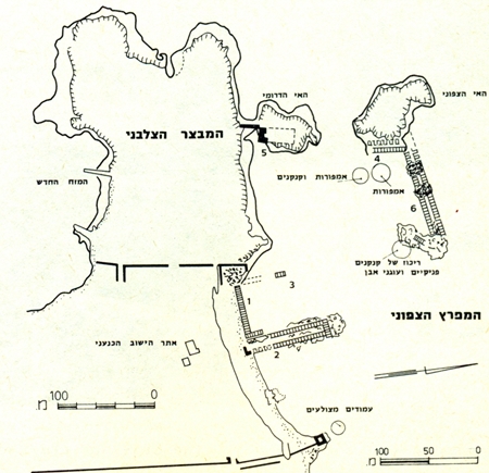
Plan of the northern harbour. (Source: The Archaeological Survey of Israel)
Over the years, Atlit has been the site of numerous surveys and archaeological excavations. The first excavation took place between 1932-1936 and 1938, led by British archaeologist Cedric Norman Johns, head of the Mandatory Department of Antiquities. This excavation focused on the Phoenician settlement. The harbor was discovered in the 1960s by the Israel Exploration Society. In the 1970s, the harbor was surveyed by the Center for Maritime Studies at the University of Haifa, led by Professor Avner Raban and Dr. Linder. Subsequently, Dr. Haggai Erlich dated the harbor using carbon-14 analysis. In 2002-2003, the harbor site was excavated by Professor Raban and Dr. Erlich.
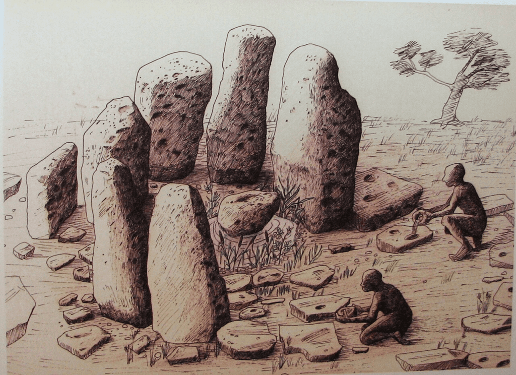
Sunken Neolithic village (7th millennium BC)
The remains of the village were discovered approximately 400 meters offshore from Atlit, at a depth of 8-12 meters. The findings date back to the Pre-Pottery Neolithic period (7th millennium BCE). The village likely stood on the southern bank of the Oren River.
Underwater excavations yielded numerous artifacts, including the remains of buildings and one of the world’s oldest water wells. The villagers engaged in fishing, cattle and sheep herding, and wheat cultivation. A unique structure consisting of several large kurkar stones with cup marks arranged in a circle suggests ritual activity at the site. Additional findings include bone tools, basalt grinding bowls, numerous flint tools for processing hides and meat, and arrowheads for hunting.
Near the village houses, individual graves containing about 15 skeletons were discovered. A study by Professor Israel Hershkovitz of the Tel Aviv University School of Medicine identified one of the skeletons as one of the earliest known cases of tuberculosis in the world.
In 1985, a maritime survey near Atlit led by archaeologist Ehud Galili revealed a prehistoric settlement. Several excavation seasons were conducted at the Neolithic village of Atlit in 1986, 1989, 1990, and 1993 by the Israel Antiquities Authority and the University of Haifa under Galili’s direction.
By Hanay, CC BY-SA 3.0, https://commons.wikimedia.org/w/index.php?curid=15044105
The Phoenician Settlement at Atlit (1st millennium BC)
The Phoenician settlement at Atlit was relatively small and included a port, south of the main Phoenician port at Dor. It was built over earlier remains from the Middle and Late Bronze periods (2nd millennium BC). Excavations uncovered a gate with two towers and a cemetery that featured a jar burial for a child. Evidence of burial practices typical of the Phoenician world includes cremations from the 8th century BCE and earth burials from the 6th century BC. This settlement persisted until the Persian and Hellenistic periods (6th-1st centuries BC).
The port was constructed around a natural bay sheltered from the winds and included a 38-meter-long pier. The construction technique of the port is recognized as Phoenician, with similar methods found at several 11th-century BCE sites in Lebanon. This technique involved wash basins and collection pools designed to prevent sediment from accumulating at the bottom of the port. Stones and pebbles brought from northern Syria and Cyprus indicate the Phoenicians at Atlit had trade connections across the Mediterranean basin. Researchers suggest the port was built in response to the increased demand for metal imports by the Kingdom of Israel in exchange for agricultural products.

מאת אסף.צ מוויקיפדיה העברית – הועבר מ- he.wikipedia לוויקישיתוףעל ידי מתניה., נחלת הכלל, https://commons.wikimedia.org/w/index.php?curid=9497957
Crusader Period at Atlit
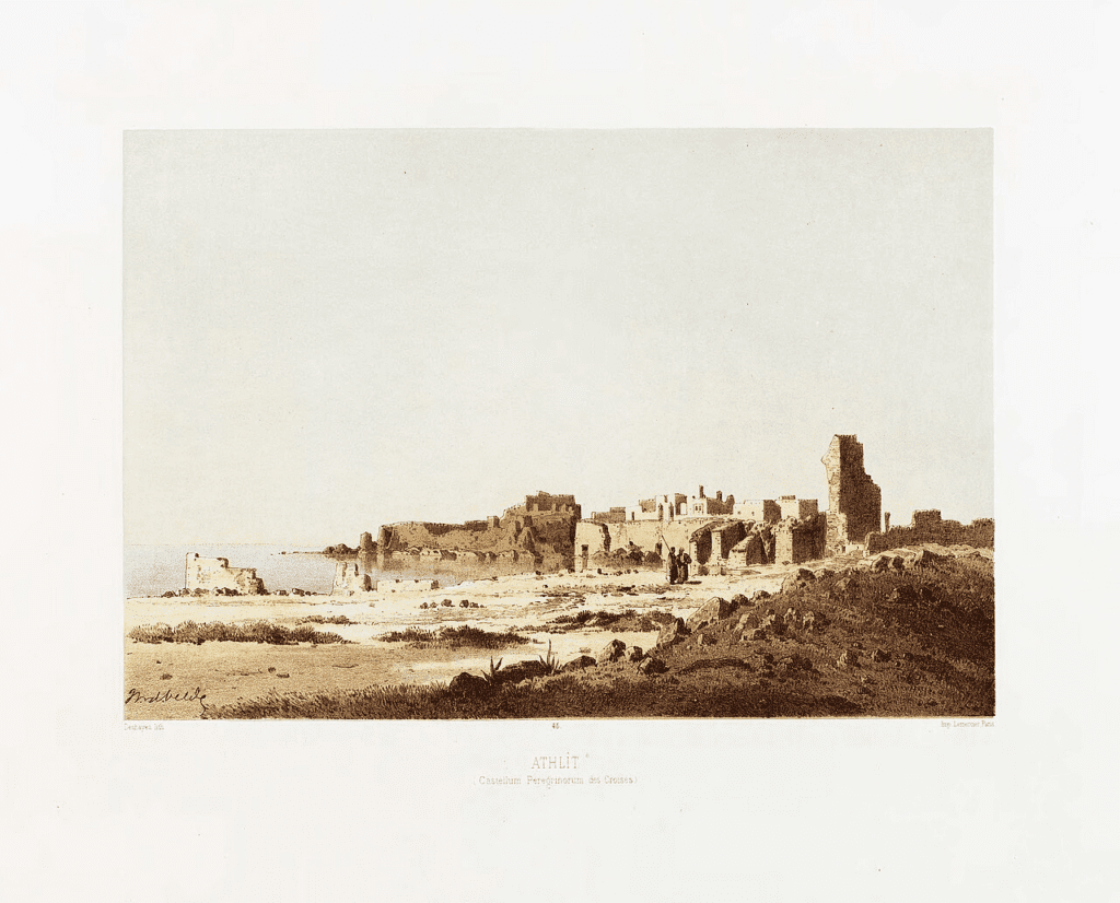
This period is the most prominent and extensive in the history of ancient Atlit. A Crusader settlement was established, and on the peninsula stood a fortress named “Castellum Peregrinorum” (Pilgrims’ Castle), known in French as “Château Pèlerin.” The Crusader presence began in 1103 CE. In the area formerly known as “Khirbet Dustrey” (mentioned in the 4th century CE), a small fortress called “Le Destroit” was built to protect pilgrims en route to Jerusalem. Near the fortress lies an ancient kurkar quarry, where the letters ‘A’ and ‘T’ were found carved in ancient Phoenician script, possibly marking the boundaries of the settlement of Atlit.
The small fortress stood for about a hundred years until the broader Crusader settlement at Atlit, during which a large castle was constructed on the peninsula. Historian Oliver of Paderborn noted that a cache of Phoenician coins was likely discovered during construction, which helped finance part of the castle’s building costs.
The fortress withstood a massive Muslim attack in 1220, prompting the Crusaders to settle around it. Excavations revealed a church, residential buildings, stables, and granaries. By 1265, the Mamluk ruler Baybars destroyed much of the fortress, but most residents remained. The castle was abandoned in 1291. The upper layer of Jones’ excavations at Atlit uncovered pottery and coins associated with the Templar presence from 1217 to 1295 CE. Under the Ottoman Empire, a significant portion of the fortress was dismantled for secondary construction purposes.
By Charles William Meredith van de Velde – File:Le_Pays_d’Israel.pdf, Public Domain, https://commons.wikimedia.org/w/index.php?curid=95021738
Sources:
Arad, H. 2013. Phoenician Atlit and Its Newly-Excavated Harbour: a Reassessment. Tel Aviv Journal of the Institute of Archaeology of Tel Aviv University. Pp. 43-60.
Arad, H. 2010. Report on Underwater Excavation at the Phoenician Harbour, Atlit, Israel. The International Journal of Nautical Archaeology 39.2: Pp. 278–285.
Arad H. and Artzy M. 2007. The Harbor of Atlit in Northern Canaanite/Phoenician Context. Near Eastern Archaeology , Vol. 70, No. 2, pp. 75-84.
C.N.Johns, Atlit. In Stern, E. (ED). 1993.. Encyclopedia of Archeological Excavations in the Holy Land. Vol 1. Pp 112-118 The Israel Exploration Society. Carta. Jerusalem.
Raban, A. and Linder, E. MARITIME ‘ATLIT . In Stern, E. (ED). 1993.. Encyclopedia of Archeological Excavations in the Holy Land. Vol 1. Pp 118-120. The Israel Exploration Society. Carta. Jerusalem.
Biblical Hiking map