

Location
Tel ‘Ira, also known as Khirbet Ghara, is located in the Beersheba Valley, in the Negev desert. Positioned on a chalk hill 514 meters above sea level, it is at the southern end of a spur of the Hebron Hills. The site spans slightly over 6 acres, encompassing the entire hill, which is steep and isolated.
Identification
The biblical identification of Tel ‘Ira is uncertain. Suggestions include:
- Kabzeel, as per Y. Aharoni, due to its location in the Negev (Joshua 15:21).
- Ramah of the Negev, suggested by A. Lemaire, N. Na’aman, and A. F. Rainey, considering its high altitude (Joshua 19:8).
- Eltolad, proposed by B. Mazar (Joshua 15:30). However, excavations have not revealed an occupation level from the 10th century BCE, which is significant for some of these identifications.
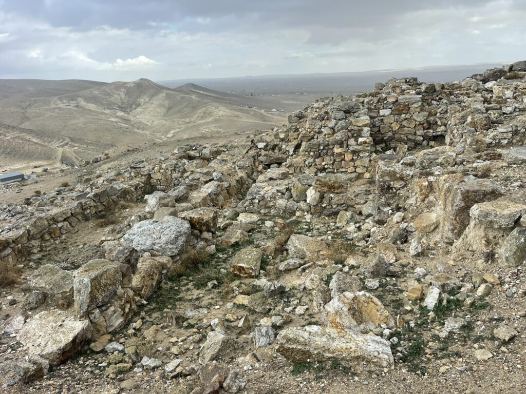
History
Excavations revealed nine settlement layers dating from the 27th century CE to the early Arab period (eighth century CE). The remains, which are impressive and outstanding in scope, were discovered from the Iron Age and the Byzantine period.
Biblical Context
The biblical context of Tel ‘Ira is primarily speculative due to the uncertainty in its identification with any specific biblical city. The suggestions of Kabzeel, Ramah of the Negev, or Eltolad are based on geographical and historical considerations, but lack definitive archaeological evidence.
Excavations
The site was surveyed in the early fifties by D. Alon ,even years of excavation were conducted at the site in the years 1979-1987, the first of which (1979) was conducted as part of emergency surveys and rescue excavations in the Negev on behalf of the Department of Antiquities and Museums and was carried out by a delegation from the Institute of Archeology of Tel Aviv University headed by M. Kochavi and by a delegation from the Institute of Biblical and Antiquities Nelson Glick under the management of A. Byrne and R. Cohen. The other seasons were conducted on behalf of the Institute of Archeology of Tel Aviv University under the direction of Y. Beit-Arie and Y. Finkelstein.
Findings
Iron age
In a layer from the Iron Age (layer VII: from the end of the 8th century to the first half of the 7th century BCE) the remains of a city were discovered in a form that extended over its entire area. In the eastern part, the gate and public buildings were uncovered, and in the other areas, private houses were uncovered. The wall was preserved in some places up to a height of over 2 m. The gate in the eastern wall of the city has six cells and two towers were uncovered from it. These remains of the wall and the gate testify to its importance, and it can be assumed that the city served as an administrative center of the Kingdom of Judah and a main fortress city on its southern border. There is no doubt that one of the reasons for this is the site’s strategic location, overlooking the Be’er Sheva valley and its roads and from where the southern border of the kingdom can be defended.
Byzantine period
In the Byzantine period (stratum II) there was a large and dense settlement in Tel. The Israeli wall continued to fortify the city, and it was restored and raised along its entire length.
In the east of the mound, a large monastery was uncovered, covering an area of 800 square meters. In the center of the monastery is a large courtyard, paved with limestone slabs, with a plastered pit in it. The monastery is divided into three wings, in the central wing a church paved with mosaics decorated with geometrical and vegetal patterns with various figures was uncovered, as well as a dedicatory inscription to Peter.
Sources
Stern, Ephraim-New Encyclopedia of Archaeological Excavations in the Holy Land 2-Israel Exploration Society (1993)